Data
Data
Intel and Cyberhawk use UAS to inspect gas terminal in Scotland
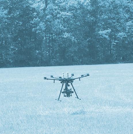
Intel and Cyberhawk have announced that they successfully inspected a gas terminal in St Fergus, Scotland using an Intel Falcon 8+ UAS.
The companies say that traditional inspections of this scale require facility shutdowns, which could take days to weeks to bring the plant offline and make accessible for workers. Once these plants are offline, the workers rely on harnesses and cable equipment to hang midair while manually collecting information on a structure, which can be both dangerous and time consuming.
 and Chris Fleming of Cyberhawk, an aerial inspection and surveying company, use an Intel Falcon 8+ system during the inspection of an operating gas terminal in St Fergus, Scotland. Photo courtesy of Intel.")
Mapping the Future: How Drones and Geospatial Technology Are Changing How We See the World
The ability to gather accurate data and images efficiently and economically has drastically improved how companies and individuals map their holdings and surroundings. Drone missions can gather data and images once only available via satellite. Increased availability has led to more markets investing in mapping capabilities, as they recognize the benefits of accessing clear and accurate renderings.

Geomni says UAS can help solve tree coverage imagery problem
Details of residential and commercial structures can be obscured by overreaching tree canopies when satellite and aerial imagery are used to document property values and evaluate roof damage, but using UAS to collect aerial images of rooftops could solve this issue according to Geomni, a Verisk business.
Geomni, which provides information about residential and commercial structures by utilizing remote sensing and machine learning technologies, says that since UAS can operate in close proximity to the subject, they can provide extremely detailed images, and “deliver superior sub-centimeter resolution for more accurate and detailed data.”

GA-ASI's MQ-9 successfully used during U.S. Naval exercise
General Atomics Aeronautical Systems, Inc.’s (GA-ASI) MQ-9 Predator B Remotely Piloted Aircraft (RPA) was used to successfully demonstrate the remote detection and tracking of submerged contacts, such as submarines, during an Oct. 12 U.S. Naval exercise.
GA-ASI participated in the successful demonstration of new maritime patrol capabilities, which included anti-submarine warfare, during the flight that took place over the Southern California Offshore Range (SCORE) west of San Clemente Island.

3D Robotics announces integration of its Site Scan with Autodesk BIM 360
3D Robotics (3DR) has announced the integration of its Site Scan UAS data platform for construction and engineering professionals with Autodesk BIM 360, which is a project management tool for virtual construction managers and field teams.
Made possible through the Autodesk Forge platform, this “one-of-a-kind partnership” makes it “easier than ever” for project managers, engineers, subcontractors, superintendents and other members of project teams to access UAS data, and use it in their day-to-day work.
Velodyne LiDAR Inc. to integrate its LiDAR sensors into BoE Systems' UAV fleet
Through a new partnership with Kansas City, Missouri-based BoE Systems, Velodyne LiDAR Inc. will integrate its VLP-16 Puck and Puck LITE 3D LiDAR sensors into BoE Systems’ UAV fleet for geospatial data collection and analysis.
The companies say that through this integration, BoE Systems can provide full 360-degree imaging of geography and equipment for industries that need quick, safe, and accurate aerial inspections, such as transportation, construction and agriculture, to name a few.
After collecting imaging data, BoE Systems processes that data, and works with customers for “tailored analysis and inspection reports,” which allows them to address immediate and future needs and compliance issues.
Black & Veatch and Aeryon Labs utilize UAS to enhance utility asset data
Black & Veatch and Aeryon Labs have collaborated to launch an end-to-end asset management inspection system that uses UAS technology for global energy clients.
Using Aeryon’s commercial UAS hardware, software and services, crucial infrastructure condition data can be captured, and that data is integrated by Black & Veatch into the existing enterprise asset management (EAM) systems of a utility.
This streamlined system by Black & Veatch and Aeryon Labs expedites inspection times, lowers inspection costs, and speeds up the integration of data into EAM systems.
HAZON Solutions and PrecisionHawk to integrate technologies through new partnership
Through a new partnership announced on Oct. 25, HAZON Solutions and PrecisionHawk will look to provide better UAS safety for commercial UAS operations, by integrating their respective technologies.
Beginning in early November, PrecisionHawk’s Low Altitude Traffic and Airspace Safety (LATAS) platform will be accessible within the HAZON Drone Management System (DMS), which is HAZON’s UAS fleet management software.
 platform, photo courtesy of Newswire.com.")
Unmanned Systems: Security Without Compromise
With increasing deployment of autonomous vehicles and unmanned systems, security and data safety are key priorities for both manufacturers and consumers.
Networks are inherently vulnerable to cyber related threats and systems failures. Reliance on unverified or open channel communications and external input sources can open the door for false (or falsified) data, invalid mission throughput or other critical operational command failures. Whether these threats come via erroneous component failures or intentional malicious activities, building up your system's ability to defend against these threats is crucial.